This website uses cookies to guarantee you the best possible service. By using our website, you agree to our privacy statement and the use of cookies. Find out more.
Round-the-lake cruise
The boat crew and the GASTRONAUTIC AG team are looking forward to welcoming you on board. Discover some exciting destinations and information on a round-the-lake cruise on Lake Zug.
Cham
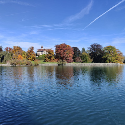
We dock in Cham and turn in front of St. Andreas Castle. The former castle dating back to 858 AD was transformed into the present-day beautiful residential palace with park by Ms Adelheid Page-Schwerzmann and her son Fred in 1903. From the boat you can also see the slender, approx. 75-metre tall steeple of the St. Jakob parish church (late Baroque, 1785) of Cham.
The Helvetians gave the place the name «Kama», which roughly translates as «village». The Romans adopted this name and then, when the Alemanni moved in, they renamed the village «Chama». Cham gained a town charter in 1360. Chom was first documented in 1491 and is the oldest documented place in the canton of Zug.
Schloss Freudenberg
The former «Freudenberg country house» was built between 1929 and 1933 by Erwin Hürlimann (general director of Swiss Re) for himself and his English wife Eleanor, née Ridge, and later Lady Glover. Former British prime minister Margaret Thatcher spent a summer holiday there as a guest of Lady Glover, and planted a tree with the help of Russell Page, who primarily worked for the French and Belgian aristocracy.
Buonas
The municipality of Buonas became well-known through Peter von Hertenstein, who founded the Papal Swiss Guard in 1506 and escorted the first Swiss guards to Rome. Buonas is also home to the largest golf course in Switzerland.
Peninsula and Schloss Buonas
The Buonas peninsula with the castle of the same name is a highlight on Lake Zug. The name Buonas means «beech-covered promontory» and refers to the forest and the shape of the peninsula. According to the inscription in the archway, the former castle dates back to 1071. The place name is mentioned for the first time in a deed of donation dated 22 January 1130 which mentions the knights «of Bochunna». The marriage of Adelheid von Buonas to Ulrich von Hertenstein marked the beginning of the 400-year rule of Buonas by the Lords of Hertenstein (~1250–1654).
The castle was burned to the ground in 1478 and rebuilt in 1494.
In 1871, the property was passed on to Carl August von Gonzenbach-Escher, the former director of the Zurich machine factory Escher-Wyss, who turned the castle grounds into a park.
Since 1997, the peninsula has belonged to the pharmaceutical company Roche and is not accessible to the public. Roche runs a training and conference centre here.
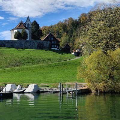
Risch
Once we have sailed around the peninsula, you will see Risch jetty in the distance. Above the jetty stands the church of St. Verena of Risch. According to archaeological investigations, this church was built on top of six older establishments, of which the first establishment dates back to the 8th or 9th century. It is the oldest and most important church in the municipality of Risch and very popular for weddings.
Pilatus
In the background, you can see Lucerne's local mountain, Pilatus, at 2,128.5 metres above sea level (the highest peak along the Tomlishorn) and a little further to the left the Stanserhorn at 1,898 metres above sea level.

Chiemen peninsula (narrowest point of the lake)
The narrowest part of Lake Zug is less than 1 km wide and separates the lower lake from the upper lake. Lake Zug spans 38.4 km2 and is situated at 413 metres above sea level. With a maximum length of 13.7 km, a maximum width of 4.6 km and a shoreline of approx. 43.2 km, it is the tenth largest lake in Switzerland. Three cantons form the lake shore. The entirety of the lower lake, including the municipality of Walchwil, is part of Canton Zug. The upper lake lies in Canton Schwyz, and the Chiemen peninsula is part of Canton Lucerne. The deepest point is situated between Immensee and Walchwil and measures 198 m.
Flora and fauna around Lake Zug
There are currently 32 species of fish in Lake Zug. The edible fish, which include whitefish, Zug lake char (an indigenous species of Arctic char), pikeperch and pike, are of economic importance. First mentioned in 1281, Zug lake char (Rötel) were used as a method of payment in the region right up until the late Middle Ages.
Immensee
Immensee was first mentioned as Imisee in 1048. The Hohle Gasse, which links the municipality to the district capital of Küssnacht, is also famous. Hohle Gasse is said to be the place where the bailiff Hermann Gessler was murdered by William Tell in 1307. Here, the distance between Lake Lucerne and Lake Zug is the shortest, at approx. 2.5 km.
Lake Lucerne is situated approximately 19 m higher than Lake Zug.

Rigi
Also known as the «Queen of the Mountains» (regina montium in Latin). At 1,800 metres above sea level, the Rigi (highest peak > Rigi Kulm) is one of the most-visited mountains in Switzerland and is a mountain for all four seasons with beautiful hiking trails all year round. The name Rigi comes from the geological composition of the mountain, bands of rock that are known as Riginen. These are geological layers that are clearly visible on the Rigi's north face and as a molasse massif primarily consist of conglomerate (various types of pressed rock). You can easily reach the peak of the Rigi on the cogwheel train from Arth-Goldau or the Kräbel Rigi-Scheidegg LKR gondola from Goldau. There are other options on the Lake Lucerne side from Vitznau (another cogwheel train) or from Weggis on the panoramic gondola.

Arth
Arth is the southernmost point of Lake Zug and well-known for its Wildlife Park in Arth-Goldau, which was founded at the beginning of the 1920s. On 2 September 1806, the Goldau landslide from the Rossberg took place, destroying the village of Goldau. To this day you will still find large boulders between the Wildlife Park and Lake Lauerz, which serve as a reminder of the catastrophe. The key railway hub of Arth-Goldau was later built on top of the rubble.
Walchwil
Walchwil sits nestled on the slope between the Zugerberg and Rossberg. Because of this, Walchwil is often referred to as the «Zug Riviera» or the «Nice of Zug» . The municipality stretches from 413 metres above sea level (lake level) to 1,204 metres above sea level (Hagegg). The main specialities that thrive in Walchwil include sweet chestnuts, figs, kiwis and grapes. Walchwil is also known for its many fruit trees – especially cherry trees, which produce the cherries used to make the famous Zug kirsch liqueur.
Oberwil
In the background to the upper left of the slope, you can see the «Lake Zug Clinic», formerly known as the «Franziskusheim», the centre for inpatient psychiatry and psychotherapy. This is an institution from the Barmherzigen Brüder von Maria-Hilf (Brothers of Mercy of Mary Help of Christians) and has been run as a concordat clinic for the cantons of Uri, Schwyz and Zug since 1982. The clinic was founded in 1909 by Capuchin Father Rufin Steimer.
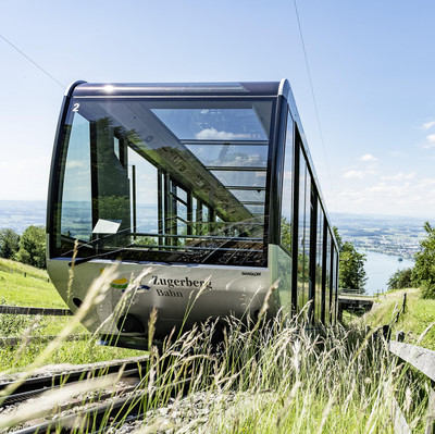
Zugerberg
The Zugerberg, which is geologically comprised of the same layers of sub-alpine molasse as the Rigi, rises in the Hünggigütsch to 1,039 metres above sea level and has a high plateau of up to 2 km wide at its ridge. Between the moraines of the Reuss glacier from the Würm ice age arose the Eigenried upland moor (to a great extent in the Walchwil area), which is one of the most valuable nature reserves in Canton Zug.
The Zugerbergbahn (ZBB) travels up the Zugerberg from Schönegg valley station. This funicular can be reached via bus line 603 from the railway station. The mountain ascent takes around 6 minutes to reach 926 metres above sea level.

Zug
It is possible that the Counts of Kyburg founded the city of Zug at the beginning of the 13th century. The 52-metre high Zytturm tower in the old town is the symbol of Zug. It was built in the mid-13th century as a simple passageway. Until the construction of the second city wall, the tower served as a closeable entrance to the city. However, it was also used as a prison and a fire watchtower. The beginnings of the castle date back to around the 11th century.
During what is known as the «Vorstadtkatastrophe» (suburban catastrophe) on 5 July 1887, a shore collapse destroyed 35 buildings in the suburb, killing 11 people and making 650 homeless. The houses were caught up in a slide following piling and embankment work during the construction of a new quayside facility, which weakened the stability of the shore and caused a supporting layer of silt sand to slide away.